These walks have it all! An ancient graveyard, picturesque nature, breathtaking views, tree-lined paths and a forgotten railway. They are not just walks, but journeys through time.
Before you set off, a word about St Giles: he was a hermit monk, most likely alive in the 7th century. He was a popular medieval saint, patron of among other things lepers and people in need. In art, St Giles is usually depicted with a hind, who according to legend needed his help, having been wounded by an arrow.
Practical Matters:
Your choice of a trail: You can choose from three trails. All three start in the same place and cover the same ground on the higher level of St Giles Hill. Once you have viewed the compass, they diverge, giving you options of continuing down the hill or leaving the walk from the higher level.
Trail A: The Accessible Trail: This is the easiest to navigate and step-free pathways are available, making it accessible to everyone. It avoids the descent via steps and uneven paths. (If the walk from the city centre to the start of the trail is not accessible you could take a bus or drive to the top of the hill – 59 Alresford Rd (south side of the road), Winchester SO23 0LA.
Trail B: The Quarry Heritage Trail: This route takes you to the lower level, down a flight of steps, returning to the city centre via Quarry Road and Chesil Street.
Trail C: The Railway Trail: This route takes you to the lower level along shady paths and 42 steps, returning to the city centre via Chesil Street.
By bus: If you would prefer not to walk to start at St Giles Graveyard, you can take a short 64 bus ride from the city centre to Baring Road.
For a shorter walk: If you prefer a shorter walk, you could miss out the St Giles Hill Graveyard, and join the trail at Baring Road for St Giles Hill.
Food and drink: There are no cafes or shops. Don’t forget to bring water, especially if it’s hot. On a fine day, you might want to pack a picnic as there are many beautiful spots where you can rest and enjoy the views. Choose between sunny viewpoints on the high points or shady spots under the trees along the lower levels.
Time of day: Every time of the day has its charms on St Giles Hill. The early morning is a wonderful time to look at the views as they are well-lit. Sunset allows you to watch the city light up, and you may be lucky enough to see the pipistrelle bats come out to feed. If you take a sunset stroll, you may want to stick to Trail A, to avoid walking down the steps in the dark.
You can download a PDF of the St Giles Hill Trails.
Starting from Winchester City Centre
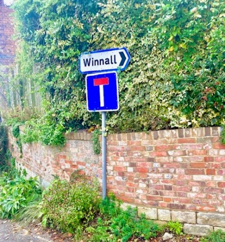
If you are walking from the city centre, starting at the Guildhall, head east and continue past the King Alfred statue and over the bridge between City Mill and the Bishop on the Bridge pub. You want to be on the left-hand pavement heading up the hill ahead. Just past the mini roundabout, you will find St John’s Street on the left. Turn into St John Street. You will soon see St John the Baptist church on your left. A Grade 1 listed building dating back to the early 13th century, this is Winchester’s oldest parish church and is still in continuous use. From the church, Continue up St John’s Street until you reach the crossroads and the sign for a dead end Turn to your right up Blue Ball Hill towards Winnall.
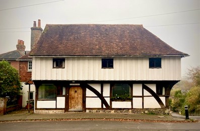
On the corner, you will see a half-timbered building, which was once the Old Blue Boar Inn, built in about 1340. Opposite, you will find the entrance to Joyce Garden on your right through a gap in the hedge, offering spectacular views of the city. Directly opposite the park entrance is the house to which it once belonged, St John’s Croft, which once served as a Georgian rectory. Follow the patch that winds through the garden to a red gate. When exiting from the top of Joyce Garden, turn left and walk up the road around the corner along Alresford Road. Continue along Alresford Road past a brick wall and Baring Road on the righthand side of the road to the iron gates of the St Giles Graveyard. You will need to cross Alresford Road to reach the Graveyard, take care because it is a busy road, there are two possible crossing places, opposite the entrance to Baring Road or opposite the gates at the entrance to the Graveyard.
St Giles Hill Graveyard
The Victorians

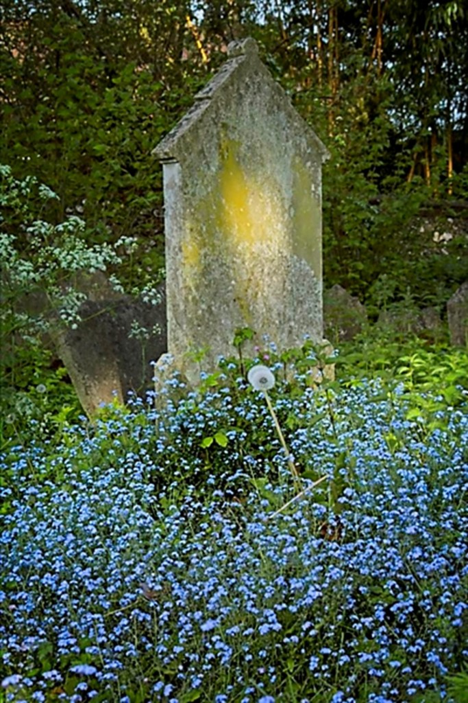
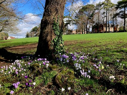
Our walk starts at the iron gates of St Giles Hill Graveyard, following the path lined with lime trees. This area was added to an older graveyard in about 1870. The earliest legible grave is that of Mary Roberts, wife of Charles Collins, who died in 1870; the last is that of Flossie Jane Hughes, who died in 1973.
Many of Victorian Winchester’s great and good are buried here. One gravestone to catch the eye is on the left of the path, for Margaret Baron, William Colson and their sons William and Benjamin Bishop. The latter has a claim to fame: there is a cul-de-sac named after him in Winchester. In 1895 he bought a brewery in Chesil Street from the Pointer family, also buried here. He changed the business’s name to B&B Colson & Sons and at one time the brewery owned nine pubs in Winchester, selling ‘Colson’s Genuine Ales and Stouts’.
When you walk to the end of the lime tree path the land rises to both left and right. The end of the path marks the boundary of the old graveyard. The way ahead is pathless and the ground is uneven.
The ancient graveyard
It can be difficult to pick out, but a slight mound to the left marks the site of the Chapel of St Giles. Today, there is nothing left of the chapel above ground. It was built by Normans to replace an original Saxon chapel and was left abandoned after the reformation of the church in England in the 16th century.
The upper graveyard has older burials, including the earliest legible gravestone, that of William Gill Jr, who died in 1694 at only 19 years old. His gravestone is among other Gill gravestones under a tree that has grown significantly since they were buried here.
The gravestones and box tombs of the Lucas family, who were significant builders in the city during that time, dominate the southeast corner of the graveyard. Many were builders and the box tombs are markers of their social standing and status.
Rather romantically, in the 18th century, there was a fashion for double headstones for married couples. In this cemetery, you can see several examples, including those of Thomas and Joanna Pinnock, who have rested here together since 1779.
You might also spot a gravestone depicting a skull and crossbones, a symbol associated today with pirates. The Roblet buried here was probably not a buccaneer, and this emblem is more likely to be a memento mori, a reminder of mortality.
You can also spot gravestones decorated with trumpets and delightfully chubby cherubs.
You can easily spend hours here, enjoying the peace and the nature and reading the gravestones. When you’re ready to leave, go back the way you came and turn left out of the gates and take the first left onto Baring Road. Follow the road until you reach the green area, take the path just to the right of the road and parallel to it, to continue your journey up the hill.
St Giles Hill
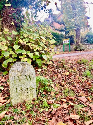
After a few yards to the left of the path, almost opposite the ‘Private Road’ sign on the road, there is a curious stone engraved ‘BW 1836’ set into the grass. It is thought this marks the Borough of Winchester boundary at the time.
Odd neighbours
A little further on at the corner of Northbrook Avenue stands Earlsdown, a large Victorian house with a fascinating history. Built in 1883, it was the first residence to grace the top of St Giles Hill. But it’s what lies beneath that truly intrigues. In 1893, during road construction, a discovery was made—a skeleton and a sword were unearthed. More than a decade later, in 1907, while digging to install a children’s swing in the garden, more Saxon skeletons were uncovered, revealing that Earlsdown sits on what was once part of the ancient Saxon cemetery. The people buried were potentially noble as they were buried with such objects as swords, shields, knives, daggers, cups and spears. The house itself seems to boast an air of nobility, with a majestic coat of arms displayed prominently on its exterior, suggesting the presence of an earl. But don’t be fooled—it’s a clever, pretentious façade, the 19th-century owners had no right to such an honour. The real story of Earlsdown lies not in its grandeur, but in the mysteries buried beneath its foundations.
Further along the path, the neighbouring modern house boasts two plaques on its gateposts, one for winning the Time for Design award in 1987 and the other for winning the Winchester Preservation Trust Award in 1984. Looking at the house, you can see its mirror glass construction reflecting the view behind you.
This is a good moment on your walk to sit on one of the benches in front of these houses to admire the view and read a little about the park. A favourite bench bears the romantic inscription ‘I could sit here with you for hours.’
A bit of history about the park
The land on which the park was built had long belonged to the Bishop of Winchester. Reforms to the Church in 1878 permitted its sale for development. Before the land was auctioned, an area of 8 acres, 2 roods (a rood was a quarter of an acre) and 15 poles (there were 40 poles in a rood or 160 in an acre) on the summit and slopes of the hill was offered to the Winchester City Council, with the stipulation that it be used exclusively for public exercise and recreation.
The landholdings were further expanded in 1894, when Thomas George Baring, the Earl of Northbrook, generously donated six plots of freehold building land to the Winchester City Council. These plots, purchased for £10,815, included a quarry and lime works. The streets surrounding the area, Northbrook Close and Baring Road offer subtle clues to his involvement in the development.
The Mayor of Winchester at the time was Thomas Stopher, an architect, and in the Victorian tradition, he seized the opportunity to create the park for all classes of people, designing a refuge from the city’s increasing bustle and industrialisation, a place for leisure activities and promenading. He wrote of the park, ‘I think all good citizens will rejoice in its possession as one of the most delightful spots in the city.’
Continue along the same upper path to the top of the steps and turn right, following the path in a clockwise direction. At the next bench, you can stop and look to your left for a view of St Catherine’s Hill Nature Reserve. At the top of the hill are the earthworks of an Iron Age fort, and the buried ruins of a Norman chapel which was the reason for the site’s name.
After viewing St Catherine’s Hill, take the next path to your right to a wrought-iron bench.
Paula Moran seat
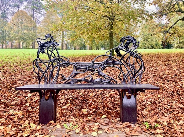
This bench is dedicated to Paula Moran, a beloved member of the Winchester community who passed away in 1994. Crafted by blacksmith Richard Bent, the bench is a work of art made from hot-forged steel, with a backrest that features a beautifully detailed running fox. Paula, who worked at the City Council, was affectionately nicknamed ‘Fox’ by her husband Peter due to her striking long red hair. Peter collaborated with Richard Bent to design the bench, which was funded through contributions from Paula’s family and the Winchester City Council.
Paula and Peter lived near St Giles Hill and frequently walked their dog there, making it a place of special significance to them. This connection inspired Peter to choose this spot on the hill for the bench, a fitting tribute to Paula’s memory and their shared love of the area.
Continue along the path and turn to your left, following the path down to the viewing point.
The viewing point
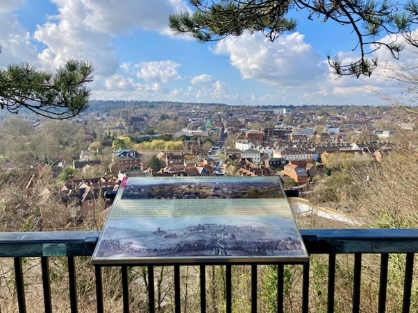
Winchester and its history are laid out before you.
- The High Street, following its ancient path through the chalk downs, serves as the main artery of this storied city. This was the route of the Roman Road past the Forum of Venta Belgarum (the Roman name for Winchester).
- At its heart stands the statue of the Saxon King Alfred the Great.
- To the left, the imposing silhouette of Winchester Cathedral dominates the skyline. Ordered by William the Conqueror, its construction began in 1079, replacing the earlier Saxon church.
- Adjacent to the cathedral lie the ruins of Wolvesey Castle. Once the seat of power for the Bishops of Winchester, the castle was built by Bishop Henry de Blois in the mid-1100s.
- Further to the left stands Winchester College, a private school founded by Bishop William of Wykeham in 1385.
- The green clock tower to the left of the High Street is the Guildhall, erected in 1873.
- At the top of the High Street is the old West Gate, a surviving fortified medieval city gateway which now houses a museum.
- On the horizon to the right of the High Street, the slender green spire of Queen Elizabeth II Court was completed in 1960. To the left are the Victorian barracks built in 1901, on the site of the King’s House built for Charles II in the 17th century.
Leave the viewing point.
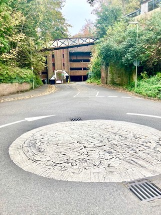
The compass
Next to the viewing point stands a stone plinth topped with a circular plate compass, serving as both a practical guide and a piece of historical significance. The inscription on the plate reads: ‘Saint Giles Hill: The great fair at Saint Giles, granted to Bishop Walkelin by William Rufus, was held in September for several centuries near this spot. Waltheof, the last Saxon Earl, was executed on the 31st of May 1076 by order of the Conqueror.’
This inscription commemorates a number of significant events in Winchester’s history. The fair at St Giles, a major medieval market, was a vital economic and social event for the region, lasting several centuries. The mention of Waltheof, the Earl of Northumbria, recalls a darker chapter. Waltheof was one of the most prominent English nobles during the turbulent years following the Norman Conquest. William the Conqueror only half trusted Waltheof, so, to ensure his loyalty, he married him to his niece, Judith.
However, Waltheof conspired against the king and when the plot failed he sought William’s forgiveness by confessing his involvement. Despite his confession and an initial appearance of clemency from the king, Waltheof was eventually arrested, tried for treason and sentenced to death. He was beheaded on 31 May 1076, on St Giles Hill, and his death marked a key moment in the suppression of Anglo-Saxon resistance to Norman rule.
For those familiar with Winchester, the place names on the compass provide a glimpse into the city’s evolving landscape. Some names have changed or taken on new purposes over time. For instance, St Mary’s College, once a prominent institution, is now commonly known as Winchester College. The compass also references the Lido, an outdoor swimming pool that was once a popular attraction despite England’s unpredictable weather. Built in the early 1930s, the Lido was not only a place for swimming but also a concert venue. Notably, the Rolling Stones performed there in December 1963. Unfortunately, the Lido closed in the late 1970s, and the site has since been repurposed as a sports club.
You may want to sit on one of the benches facing the city to read a little about more about the great fair at St Giles.
A bit of history of the fair
In 1096, King William II, also known as William Rufus, granted Bishop Walkelin of Winchester the right to hold a fair on St Giles Hill during the three days surrounding the feast of St Giles: the vigil, the feast day on September 1, and the day following. This event quickly grew into a major international affair, drawing merchants from across England and Europe who came to buy and sell a wide variety of goods. The fair became a lucrative enterprise for the Bishops of Winchester, who established an office on the hill – later known as Palm Court – to manage the event and oversee the income generated from the three toll gates, through which all attendees had to pay to enter.
The fair was meticulously organised, with different sections allocated to various trades, ensuring that merchants could display their wares in an orderly fashion. Even the monks from Winchester Cathedral participated, operating a stall to sell their goods. At its peak in the 1200s, the fair extended over 16 days, transforming St Giles Hill into a vibrant and cosmopolitan hub. The event likely attracted a diverse crowd, including entertainers, merchants and perhaps even pickpockets, making it a lively and exciting gathering for all who attended.
Following the Black Death in the 1300s, the fair on St Giles Hill gradually declined, though it continued in a modest form as a country fair until the advent of the railways eventually brought it to an end in the early 19th century.
It is time to choose your trail.
Trail A: The Accessible Trail
Final stretch
From the viewpoint retrace your steps. As you return to Alresford Road via Baring Road, keep an eye out for a street named Palm Hall Close. Surprisingly, the name doesn’t refer to palm trees at all. Instead, it harks back to a historical site: the Bishop’s Court House, which stood here in the 1200s, the administrative hub of the famous St Giles Fair.
In its original Latin, the site was called Pavillionis Aula, but over time the name evolved –Pavillionis gradually morphed into ‘Palm Hall’. Interestingly, the court itself was also known as a ‘Pie Powder’ court, a transformation of the French term pieds poudreux, meaning ‘dusty feet’. This fittingly described the weary, mud-caked travellers who flocked to the fair in those times.
Trail B: The Quarry Heritage Trail
Starting the trail
With your back to the view, turn right and follow the tarmac path until you reach a fork, with two earth paths. Take the upper path. You may want to pause when you reach a large Beech tree, to look at the spectacular view of Winchester College. Continue along the path, past two benches until you reach the point where you join a flight of tiled steps. Take the steps down, taking care as you do so, as some of them are broken.
Historic quarry site
As you descend the steps, look to your left to see the area where a flint and chalk quarry once operated. This land, originally owned by Winchester Cathedral, was leased in 1846 to Richard Northover and Henry Dusanlov, about whom nothing else seems to be known, for £169. The lease included part of St Giles Hill, complete with lime kilns and quantities of earth and chalk. Despite the lease, the Dean and Chapter retained the right to quarry materials for the repair of the cathedral and other buildings.
Quarry manager’s cottage
As you descend, you will notice a black and white building that once served as a quarry manager’s cottage, built in the 1850s. Much of the flint used in the construction of Victorian buildings and walls in Winchester was sourced from this quarry.
Quarry Road
At the end of a path is a signpost to River Walk and South Downs Way.
Turn right here. The pavement is narrow, so exercise caution, especially if you have children or dogs with you.

At the end of a path is a signpost to River Walk and South Downs Way.
Turn right here. The pavement is narrow, so exercise caution, especially if you have children or dogs with you.
Sunny Bank
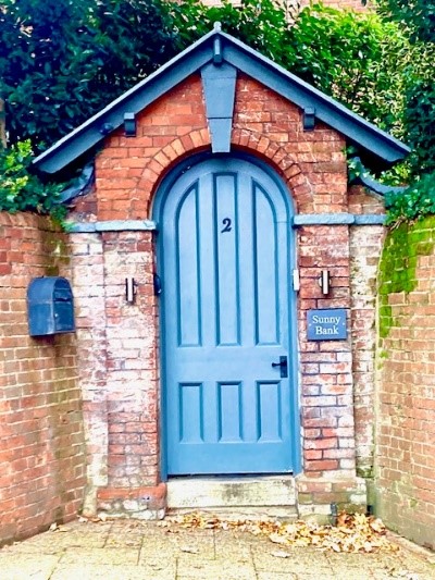
As you walk downhill, you will see the entrance to a house called Sunny Bank, 2 Quarry Road, on the opposite side. The house’s garden is enclosed by a brick and flint wall, which also marks the junction of Quarry Road and Petersfield Road. This wall, viewed from below, resembles the prow of a battleship – perhaps a design choice by a previous owner who built the wall in 1905 to evoke the feeling of commanding a ship. The ‘ship’ is best appreciated from the next junction downhill.
Continuing the walk
Continue downhill as the street you are walking along; Quarry Road becomes East Hill. When you reach Chesil Street, you’ll see the Black Hole B&B on the opposite side of the road. Turn right, continuing along the pavement until just past the traffic lights and opposite numbers 80 and 80a. On your side of the road, just before reaching a new red-brick building, take the stairway with grey railings, leading down to the road below.
Chesil Station and the railway footbridge
At the foot of the steps, look to your right to see that you have just walked across the bridge over the old railway line. You are now standing beside what was the line. With your back to the steps, turn to your left and walk along the pavement towards the mini roundabout and car park.
Just before the mini roundabout, look up and you will see a footbridge painted in the brown and cream colours of the Great Western Railway (GWR), serving as a visual reminder of the now-defunct railway line that once ran here. The footbridge overlooks the former site of Winchester Chesil Station, which opened on 4 May 1885, as part of the Didcot, Newbury and Southampton Railway.
Cross the mini-roundabout and go along the pavement into the car park. Follow the blue pedestrian pathway through the car park.
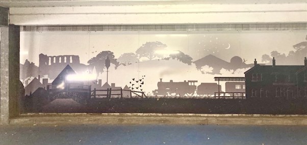
At the entrance to the car park look to your left to see a mural depicting silhouette images of the landmarks visible from the St Giles Hill observation point. Towards the end of the mural is the image of a steam train, paying homage to the abandoned railway line. This railway played a vital role during World War II, transporting munitions and troops to South Coast ports in preparation for the Normandy landings. The railway was closed in the 1960s, although it continued to transport goods for a few more years.
Continue to follow the blue pathway,ignoring an exit to your left. At the end of the blue pathway, exit the car park (there are toilets here if required) and go right into Old Station Approach.
The Old Station Master’s House
Look for a sign next to a steep stairway that reads ‘Private Access for Prospect House and Beeching House’.
Beeching House was built quite recently in the garden of Prospect House. It was named by someone with an ironic sense of humour, referencing Lord Beeching, chairman of British Railways in the early 1960s, whose notorious ‘cuts’ led to the closure of the railway.
Prospect House is the former station master’s house. From his garden, he would have had a clear view of the railway works below.
The developer who created Beeching House wanted to demolish Prospect House and build something entirely different, not knowing its history. A public consultation put things straight and the house was saved.
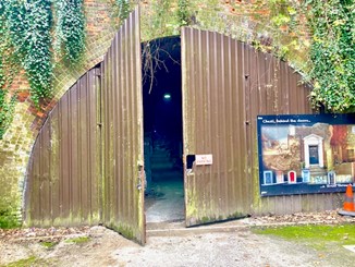
At the end of Old Station Approach, you’ll see the double doors that close off the old railway tunnel. (There is a poster on the doors that says ‘Chesil, behind doors…’ )
The railway tunnel
The tunnel, which stretches 440 yards under St Giles Hill, is now used for storage by Winchester City Council and is opened only a few times a year for tours. It’s fascinating to imagine the steam trains once emerging from this tunnel, puffing smoke and soot up towards the station master’s house above.

Final stretch
charming half-timbered Chesil Rectory, built around 1490 and claimed to be the oldest commercial property in Winchester. Cross at the pedestrian crossing in front of you, turn right and follow the road round to the left and continue ahead to Bridge Street keeping left to return past the King Alfred statue to the Guildhall, where your walk began.
Trail C: The Railway Trail
Begin this trail with your back to the view of Winchester High Street and take the path to your left (north). Follow this path, keeping the metal fence on your left, until you reach the corner where steps lead down on your left and a water fountain stands straight ahead.
Water fountain
This fountain was originally supplied with water from the Victorian-era water tower and pumping station, built by Lord Northbrook to provide mains water to the houses on the hill.
Descend the three steps and find the unmade path immediately on your left to continue your journey. Follow the tree-lined path past the lamppost all the way down to the lower viewpoint. Continue a little further until you reach a narrow passage marked by a bollard at its entrance. This passage leads to 42 steps, which you will descend.
The Didcot, Newbury and Southampton Railway
As you follow the path down, notice the fence posts – these were originally rails that have been repurposed from Isambard Kingdom Brunel’s Great Western Railway, which ran from London to Bristol.
The footbridge
The footbridge ahead is painted in the distinctive colours of the Great Western Railway (GWR), brown and cream, and serves as a visual reminder of the railway line that once operated here. This bridge overlooks the former site of Winchester Chesil Station, which opened on 4 May 1885. At the opening ceremony, the first train was due to arrive at 2:45, but the crowd gathered to see it had to wait. The train was an hour late! Lord Northbrook and his daughter Lady Emma Baring and other dignitaries greeted the train, and Lady Lloyd-Lindsay declared the line open. Soon public services to Newbury started with four trains each way on weekdays. The line was linked to Southampton in 1891, when it joined the GWR line at Shawford Junction.
Originally named Cheese Hill Station, the name evolved into ‘Chesil’ due to common pronunciation. The station was part of the Didcot, Newbury and Southampton Railway line, often humorously nicknamed the ‘Dirty, Noisy and Slow’ line. During World War I, when it was extended to serve the large army camps built on Magdalen Down at Morn Hill, the railway became strategically important, transporting munitions and troops, particularly to the South Coast ports, and again in preparation for the Normandy landings. The line fell victim to the Beeching cuts of the 1960s, a major series of railway closures, though it continued to transport goods until the mid to late ’60s.
The fence posts you saw on the way to this footbridge are remnants of broad-gauge tracks, not originally used at Chesil Station. These unwanted strips of metal from the railway yard were repurposed as fence posts.
Today, the site of the railway station is a multi-storey car park, but a section of the line still exists as a 440-yard tunnel running under St Giles Hill and emerging at Winnall.
Follow the path and steps down to emerge on Chesil Street.
Turn right and continue along the pavement until you reach Old Station Approach on your right. Turn right into Old Station Approach and pick up Trail B at The Old Station Master’s House.
Acknowledgements
These trails were developed by Lorraine Estelle in collaboration with the Friends of St Giles Hill Park.
Many thanks to Mike Biden for his encouragement and help, and to Caroline Taggart and Gavin Mann for their patience in helping the creation and in the testing of these walks.
All photographs are © Gavin Mann
I am deeply indebted to the book St Giles Hill: a Place in History (out of print) by the late Hugh Watson, Landscape Architect and long-time Cathedral Guide.
More information and resources
The Winchester Tourist Guides provide tours of the disused railway tunnel twice a year. They also provide occasional walking tours of St Giles Hill. Look at their website for prices and the dates of the next tours: https://winchestertouristguides.com/index.php/our-tours/themed-tours
The Friends of St Giles Hill Graveyard website provides a wonderful trove of information about the history of the graveyard and St Giles Hill. https://www.stgileshill.org.uk/
Time Gentlemen Please!: The Story of Winchester’s Pubs, Breweries and Hotels Past and Present by Phil Yates provided information about Colson & Sons.
